Utility
PERFECT SERVICE SOLUTION
Enhance your project by integrating our Utility Survey services with our comprehensive digital solutions, creating a seamless, coordinated record of your entire development site.
As one of the UK’s leading Ground Penetrating Radar (GPR) consultants, we’ve been delivering expert Utility Survey services since our inception.
At Surveybase, you’ll work with a dedicated team of specialists who bring the technical expertise needed to tackle large-scale and complex site surveys.
WHAT IS A UTILITY SURVEY?
A Utility Survey is a record of subterranean services within a specified area. Typically, this information is presented in plan format but can be marked at ground level to assist excavation. A Utility Survey provides a guide on the probable location of buried pipes and cables. It forms part of the wider preconstruction investigation helping to reduce the risk of accident.
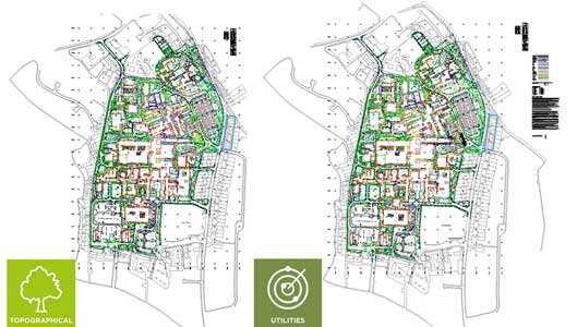
At Surveybase we use Electromagnetic Location (EML) and Ground Penetrating Radar (GPR) instruments to track the path of water mains, drainage systems, gas pipes and electrical cables across the development site. The survey procedure is controlled by GPS and coordinated with a previous Topographical Survey.
![]()
Utility
- DESKTOP UTILITY REPORT
- EML DRAINAGE MAPPING
- GPR SERVICES DETECTION
- GROUND SURFACE MARKING
- 2D AUTOCAD SITE PLAN
- FULL PAS128 SOLUTION
WHAT WILL A UTILITY SURVEY DETECT?
The latest EML and GPR instruments detect the path of metallic pipes, live power cables and drainage runs to a depth of 3M. GPR may also detect non-metallic objects and voids depending on ground conditions.
WHAT ARE THE LIMITATIONS OF A UTILITY SURVEY?
Clients should be aware that Utility Surveys are not an absolute survey solution. However, as part of the wider site investigation it provides supporting information on the probable location of buried services. Readings below 3M are not guaranteed and depend on ground conditions. Readings below concrete are limited especially when reinforced with rebar. GPR will not detect dead power cables or pipes less than 50mm in diameter. This includes plastic water and gas supply pipes.
DESKTOP UTILITY REPORT
We recommend that Clients supplement the Utility Survey by purchasing a Desktop Utility Report that identifies the known location of mains connections, such as power, water, gas, and telecom. The combined data provides an enhanced guide on the infrastructure of subterranean services.
4 TIER UTILITIES SURVEY SOLUTION
We offer a 4-tier service for Drainage Mapping, GPR Utilities Services Detection and a full PAS-128 project management solution.
LEVEL 1 – DESKTOP UTILITY RECORD
We provide a written Desktop Utility Report identifying the known location of main services.
LEVEL 2 – DRAINAGE MAPPING
We use EML instruments to locate foul and rainwater pipe runs through to the mains sewer connection.
LEVEL 3 – FULL UTILITY SURVEY
We combine EML and GPR instruments to locate buried pipes, cables, objects, and voids within the designated survey zone.
LEVEL 4 – PAS128 SOLUTION
We offer a comprehensive Utility Survey solution that meets the requirements of British Standard PAS128-2022.

UTILITY SURVEY DELIVERABLES
We will develop a Utility Survey specification that meets your precise requirements. Service options include;
- Desktop Utility Report
- Ground Surface Marking
- 2D Site Plan (AutoCAD)
Related Case Studies
How Can We Help
Surveybase has over 25 years’ experience in delivering precision digital survey solutions to the AEC industry. Let's discuss your requirements and to see how our expertise will benefit your next project.

Talk To Our Expert
Request a Quote
To obtain a quotation please email your survey brief to quote@surveybase.co.uk or use our online quote portal.


