360 Tour Matterport – Digital Twin

Interactive Virtual Tour
360 HD Imaging
PDF, JPEG, DWG & RVT Files
Schematic Plans
3D Dollhouse
Digital Twin
Online Hosting
Measurements
Tagging
Virtual Reality
Google Street View
Interactive Virtual Tour
360 HD Imaging
PDF, JPEG, DWG & RVT Files
Schematic Plans
3D Dollhouse
Digital Twin
Online Hosting
Measurements
Tagging
Virtual Reality
Google Street View
3D BIM Surveys

Your Trusted Experts in 360 Tour Matterport Surveys

Surveybase is a recognised leader in 360 Tour Matterport surveying, delivering immersive 360-degree virtual walkthroughs. With our nationwide service, we provide interactive digital twin representations of your space, complete with precise measurement data, 360-degree imagery, and exportable files for CAD or BIM integration. Our Matterport surveys offer valuable insights, ensuring complete confidence in design, planning, and project execution from start to finish.

What projects can benefit from 360 Tour Matterport Survey?

A 360 Tour Matterport Survey can benefit a wide range of projects, including:

  • Architectural Design & Renovations: 360 Tour Matterport surveys provide 3D models and floor plans, helping architects visualise space and plan designs for both new constructions and renovations.
  • Construction Projects: For construction teams, 360 Tour Matterport surveys allow for detailed documentation of existing conditions before, during, and after construction. This aids in project planning, coordination, and progress tracking, ensuring all work aligns with the original design.
  • Real Estate & Property Management: 360 Tour Matterport surveys are highly valuable for estate agents, property managers, and landlords. Virtual tours and detailed floor plans allow potential buyers or tenants to explore properties remotely, making it easier to market properties and manage space efficiently.
  • Facility Management & Maintenance: Facility managers can use 360 Tour Matterport surveys to create an accurate digital record of their buildings, making it easier to assess space, track maintenance needs, and plan future upgrades or renovations.
  • Heritage & Conservation Projects: For historical sites or conservation efforts, 360 Tour Matterport surveys provide precise digital records of a building or site, preserving the details of its structure for restoration, preservation, or educational purposes.
  • Insurance & Risk Assessment: Insurance companies can use 360 Tour Matterport surveys to document properties for claims, risk assessments,  and inspections. The detailed 3D models and measurements provide an accurate record for evaluating damages or verifying conditions.
  • Event Planning & Venue Design: Event planners and venue owners can use 360 Tour Matterport surveys to visualise and optimise the layout of event spaces. Virtual walkthroughs allow planners to plan events remotely and make informed decisions about space utilisation.
  • Retail and Hospitality: Hotels, resorts, and retail businesses can create immersive virtual tours to showcase their spaces to potential customers. 360 Tour Matterport surveys help improve marketing efforts and provide a better understanding of the layout and offerings.
  • Engineering and MEP (Mechanical, Electrical, Plumbing): Engineers can use 360 Tour Matterport surveys for accurate documentation of spaces to plan mechanical, electrical, and plumbing systems, ensuring designs fit the existing structure.
  • Legal and Compliance Projects: 360 Tour Matterport surveys can support legal projects by providing visual evidence of property conditions. They also help with regulatory compliance by offering accurate and detailed records of spaces, making it easier to meet building codes and safety regulations.

360 Tour Matterport Surveys are highly effective for projects that require rapid access to accurate spatial data, immersive virtual tours, and cost-efficient deliverables, making them an ideal solution for enhancing project planning, design, and decision-making processes.

What is a 360 Tour Matterport Survey?

A 360 Tour Matterport Survey is an advanced 3D scanning process that captures detailed digital representations of physical spaces, creating immersive 360-degree virtual walkthroughs. Using Matterport’s cutting-edge technology, the survey provides high-definition images, precise measurements, and interactive floor plans, offering clients a digital twin of the space.

A 360 Tour Matterport survey captures not only detailed imaging but also measurement and virtual reality data, which can be used for virtual tours, accurate measurements, tagging, and exporting files such as CAD, BIM, PDF, and JPEG. These versatile deliverables are ideal for design, planning, construction, and real estate professionals who require reliable, accessible spatial data for integration into their workflows and project management.

Video Tour

Tailored Solutions

We offer a flexible approach to 360 Tour Matterport surveys, providing tailored solutions that meet the specific needs of your project, including:


VIRTUAL TOUR
An immersive, high- definition 360-degree virtual tour of your building. This experience enables remote site visits, virtual meetings, and real-time condition updates, providing a convenient and efficient way to interact with the space from anywhere.
Matterport
VIRTUAL TOUR
An immersive, high- definition 360-degree virtual tour of your building. This experience enables remote site visits, virtual meetings, and real-time condition updates, providing a convenient and efficient way to interact with the space from anywhere.
3D DOLLHOUSE
A three-dimensional overview of the building, providing a digital twin of the space. This interactive model offers a comprehensive, scalable view of the entire layout, enhancing spatial understanding and planning.
Dollhouse ex
3D DOLLHOUSE
A three-dimensional overview of the building, providing a digital twin of the space. This interactive model offers a comprehensive, scalable view of the entire layout, enhancing spatial understanding and planning.
SCHEMATIC PLANS
The generation of schematic plans provides a traditional 2D view of each floor layout, offering spatial understanding, annotations, and area calculations.
Schematic Floor Plan
SCHEMATIC PLANS
The generation of schematic plans provides a traditional 2D view of each floor layout, offering spatial understanding, annotations, and area calculations.
2D CAD PLANS
Our 360 Tour Matterport surveys generate detailed 2D CAD DWG plans, providing floor layouts, reflected ceiling plans, annotations, and area calculations to support design, planning, and project execution.
2D CAD
2D CAD PLANS
Our 360 Tour Matterport surveys generate detailed 2D CAD DWG plans, providing floor layouts, reflected ceiling plans, annotations, and area calculations to support design, planning, and project execution.
3D BIM Models
Our 360 Tour Matterport surveys can generate detailed 3D BIM models for Revit, providing 3D floor layouts. Export files also include E.57 and .RCS point clouds
3D BIM
3D BIM Models
Our 360 Tour Matterport surveys can generate detailed 3D BIM models for Revit, providing 3D floor layouts. Export files also include E.57 and .RCS point clouds
PANORAMIC & HD IMAGES
Our 360 Tour Matterport surveys allow you to export high-resolution panoramic and HD images, capturing detailed visuals for documentation, presentations, and project references. These images provide an accurate record of site conditions, enhancing collaboration, design planning, and marketing efforts
HD
PANORAMIC & HD IMAGES
Our 360 Tour Matterport surveys allow you to export high-resolution panoramic and HD images, capturing detailed visuals for documentation, presentations, and project references. These images provide an accurate record of site conditions, enhancing collaboration, design planning, and marketing efforts
360 Tour Matterport – Digital Twin

Deliverables

Interactive Virtual Tour
360 HD Imaging
PDF, JPEG, DWG & RVT Files
Schematic Plans
3D Dollhouse
Virtual Reality
Google Street View

Frequently asked questions

A Matterport survey works by using a specialised 3D camera to capture detailed scans of a space, creating a fully immersive digital twin. The camera records high-resolution imagery and depth data, which are stitched together to form an interactive, accurate 3D model that can be explored online.
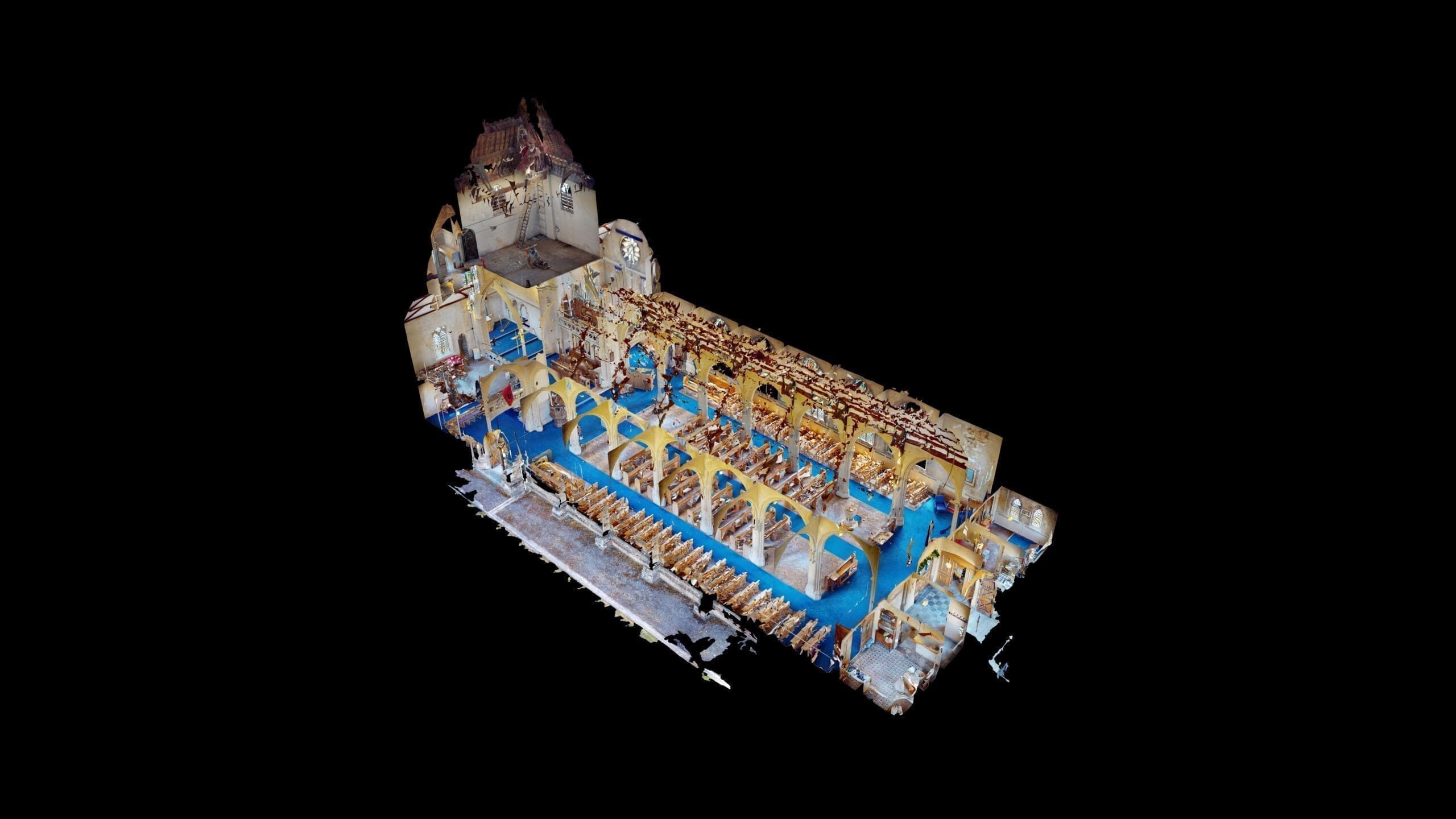
You might need a Matterport survey if you require accurate 3D documentation of a space for construction, architecture, real estate, or property management. It’s ideal for creating immersive virtual tours, capturing precise measurements, and generating detailed as-built records. Matterport surveys are especially useful for remote collaboration, reducing the need for frequent site visits, and can be exported to CAD or BIM software for further use.
The cost of a Matterport survey depends on several factors, including the size and complexity of the space, the level of detail required, and any additional services, such as floor plans, CAD/BIM exports, or customised deliverables. For an no-obligation quote tailored to your project, get in touch with us today.

Integrated Surveying Services

Unlock the benefits of integrated surveying services with Surveybase. Our comprehensive solutions combine a range of services to deliver efficient, accurate, and cost-effective results, supporting every phase of your project with precision and reliability.

Related projects

Each project highlights our dedication to accuracy, innovation, and delivering integrated surveying services. Discover how we’ve helped clients achieve successful outcomes with precise, high-quality data.

Garrison Church of St George, Salisbury

Talk to an expert

Jordan King

Managing Director

Get A Quote

How can we help?

We’re here to support your project with accurate surveys and expert advice. Get in touch today to speak to one of our experts and find out how we can help.

Request a quote

To obtain a quotation, please email your survey brief to: quote@surveybase.co.uk or use our online quote portal.